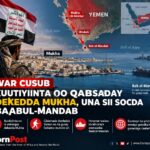
Hargeisa (HornPost) From ancient trade to the Cold War and Israel’s recognition, Somaliland’s strategic coast has drawn global powers for centuries. Geography remains the constant.
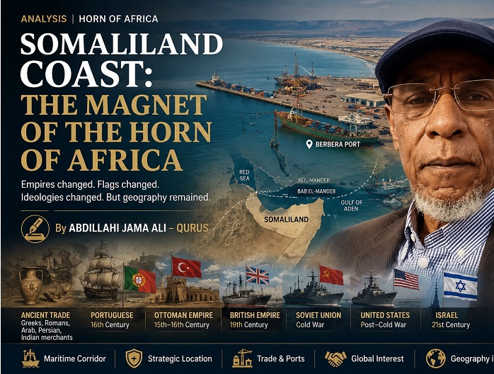
Somaliland Coast: The Magnet of the Horn of Africa.
Empires changed. Flags changed. Ideologies changed. But geography remained.
By Abdillahi Jama Ali – Qurus
There are places in the world whose importance depends largely on the power of the state that controls them.
There are others whose importance is determined by geography itself.
The Somaliland coast belongs to the second category.
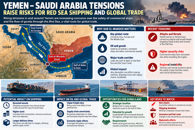
For centuries, the northern Somali coast has stood beside one of the world’s great maritime corridors. It faces the Arabian Peninsula across the Gulf of Aden and lies close to the Bab el-Mandeb, the narrow gateway connecting the Red Sea with the Gulf of Aden and the wider Indian Ocean. Through the Suez Canal, this maritime corridor connects the region with the Mediterranean and Europe.
That geography has repeatedly drawn the attention of distant powers.
The Greeks and Romans came through trade. Persian, Arab and Indian merchants entered the same commercial world. The Portuguese arrived with armed fleets. The Ottoman Empire extended its influence toward the coast. The British Empire came to protect its route to India. During the Cold War, the Soviet Union and the United States competed for strategic access to Berbera.
And now, in a new geopolitical era, Israel has recognized Somaliland.
This is not an accident.
It is part of a much older pattern.
Empires changed. Flags changed. Ideologies changed. But geography remained.
The Ancient Magnet
The strategic importance of the Somaliland coast did not begin with European colonialism.
More than 2,000 years ago, the coast was already connected to international trading networks linking Africa, Arabia, the Red Sea, the Mediterranean and the Indian Ocean.
Archaeological research has uncovered evidence of long-distance trade along the Somaliland coast, including Roman and South Arabian materials at Xiis (Heis) and other archaeological sites. Research at Heis has identified imported pottery and glass associated with the Roman and Parthian worlds, South Arabia and wider Indian Ocean trade networks.
The archaeological evidence demonstrates that the ancient coastline was far from isolated.
It was part of a commercial network linking Africa, Arabia, Egypt, the Mediterranean and the wider Indian Ocean world.
The attraction was clear:
The coast stood on the road of maritime trade.
Ancient sailors came not because the Somali coast was easy to dominate, but because it was impossible to ignore.
Persia, Arabia and the Indian Ocean World
For centuries, the northern Somali coast remained part of a much larger commercial system.
Arab, Persian and Indian merchants were drawn toward its ports and markets. The coast became a meeting place between African pastoral societies, inland trade routes and seaborne commerce.
The attraction was both geographical and economic.
The Gulf of Aden connected the coast to Arabia and the Persian Gulf. At the same time, caravans carried livestock, gums, resins and other goods between the Somali interior and coastal markets.
The foreign merchant saw the coast as a gateway.
The Somali merchant saw the sea as an opening to the world.
This was the first great magnetism of the Somaliland coast:
Trade pulled the world toward it.
The Portuguese Arrive
Then the magnet began attracting a different kind of visitor.
In the 16th century, Portugal entered the Indian Ocean with armed fleets and imperial ambitions.
Portuguese strategy was no longer simply about participating in trade. Lisbon sought to influence and, where possible, control the maritime routes linking the Indian Ocean to the Red Sea.
The Portuguese became active around the Horn of Africa and the Gulf of Aden, while the ports of the region became entangled in a wider struggle for control of maritime passages.
The issue was larger than any single Somali port.
The Portuguese understood that the southern entrance to the Red Sea was a strategic gateway.
And the Somaliland coast stood beside it.
The old commercial magnet had become a geopolitical magnet.
The Ottoman Shadow
Portugal’s arrival provoked a response from another major power.
The Ottoman Empire, expanding through the Red Sea and the wider Islamic world, viewed Portuguese activity as a threat to its strategic interests and to maritime routes connecting the Middle East with the Indian Ocean.
Ottoman influence extended to Zeila, while the wider Somali coast became connected to the competition between the Ottoman and European worlds.
The relationship was not one of simple or continuous Ottoman control. Local Somali rulers and communities retained their own authority and political agency.
Nevertheless, the strategic interest of the Ottoman Empire was unmistakable.
Portugal looked toward the Red Sea from the Indian Ocean.
The Ottoman Empire looked toward the Indian Ocean from the Red Sea.
And between these two strategic worlds stood the Horn of Africa.
Once again, the Somaliland coast had become a magnet.
Britain and the Imperial Highway to India
The British Empire viewed the coast through the lens of global strategy.
Britain’s occupation of Aden in 1839 made the northern Somali coast particularly important. The coast supplied livestock and other goods to the British presence across the Gulf of Aden.
The strategic importance became even greater after the opening of the Suez Canal in 1869.
The Red Sea route was transformed into one of the principal arteries connecting Britain with India and the wider Asian trade system. Britain could not ignore the African shore opposite Aden. Historical accounts of British Somaliland explicitly connect Britain’s occupation of Zeila, Berbera and Bulhar in the 1880s with the need to secure the route to the East through the Suez Canal.
In the late 19th century, Egypt briefly occupied important sections of the northern Somali coast, including Berbera. When Egyptian forces withdrew, Britain moved in.
By the mid-1880s, the British Somaliland Protectorate had emerged.
The logic was strategic.
Britain feared that another foreign power might occupy the coast and threaten communications through the Red Sea and Suez route.
The Somaliland coast had become part of an imperial highway stretching from:
London to Suez.
Suez to Aden.
Aden to India.
The coast was no longer merely a local frontier.
It had become part of the infrastructure of a global empire.
The Cold War: The Soviet Union Discovers Berbera
The British Empire eventually disappeared from the region.
But the strategic importance of the coast did not.
After independence, the Cold War transformed the Horn of Africa into an arena of superpower competition.
The Soviet Union developed close relations with Somalia and gained strategic access to Berbera. U.S. historical records from the 1970s describe Berbera as strategically important to Soviet naval operations in the Indian Ocean, with Moscow developing port and communications facilities there. citeturn0search2turn0search8
Berbera’s location beside the Gulf of Aden gave it military significance extending far beyond the Horn of Africa.
The Soviet Union was looking for strategic access points across the world’s oceans.
The Indian Ocean mattered.
The Gulf of Aden mattered.
Berbera mattered.
The Cold War had brought another great power to the same coast.
The Soviet Union Leaves. The United States Arrives.
Then came one of the most remarkable reversals in the strategic history of the region.
The Soviet Union and Somalia broke apart during the 1977–78 Ogaden War, as Moscow shifted its support toward Ethiopia.
The Soviets lost their privileged position in Somalia.
But the strategic vacuum did not remain empty.
The United States moved to strengthen relations with Somalia and gain access to strategic facilities that had previously attracted the Soviet Union. U.S. historical records document the subsequent American access to Berbera and other Somali military facilities.
This was perhaps the clearest proof of the argument.
The ideology changed.
The flag changed.
The superpower changed.
But the location remained strategically valuable.
The Soviet Union came.
The Soviet Union left.
The United States came.
The magnet remained.
The 21st Century: The Coast Becomes Important Again
The Cold War ended.
But the geography did not.
Today, the Somaliland coast has entered another period of international importance.
Berbera Port has developed into a major modern trade and logistics hub, while its position along the Gulf of Aden places it close to one of the world’s most sensitive maritime corridors. The port’s strategic location near the Bab el-Mandeb continues to give the area importance for regional trade and maritime security. citeturn0search1
The questions are familiar:
Who controls the ports?
Who builds the infrastructure?
Who protects the shipping lanes?
Who gains access to the coast?
Who gains political influence?
New powers are asking old questions.
Then Israel Arrived
The latest chapter began in December 2025, when Israel formally recognized Somaliland, becoming the first country to officially recognize Somaliland as an independent and sovereign state. The Israeli Knesset later described the recognition as having taken place on Dec. 26, 2025.
The decision was followed by high-level diplomatic engagement, including Israeli Foreign Minister Gideon Sa’ar’s visit to Hargeisa and subsequent discussions on diplomatic, economic and security cooperation.
This development should not be viewed as an isolated diplomatic event.
It fits into the same broader historical pattern.
Israel’s strategic environment is different from that of the Portuguese, Ottomans, British, Soviets or Americans.
But geography is again central.
Today, the Red Sea is a zone of heightened security concern. Attacks by Yemen’s Houthi movement on international shipping have increased the strategic importance of the Red Sea and Gulf of Aden.
Israel is deeply concerned about threats emanating from the region.
And the Somaliland coast lies directly across the Gulf of Aden from Yemen.
In June 2026, Somaliland Defense Minister Mohamed Yusuf Ali confirmed that Israel was providing training to Somaliland’s police and military forces while denying that there were negotiations for an Israeli military base.
One may debate the motives behind Israel’s recognition.
Diplomacy is rarely driven by a single reason.
But the strategic geography cannot be ignored.
Somaliland faces the Arabian Peninsula.
It overlooks the Gulf of Aden.
It lies beside the entrance to the Red Sea.
It stands close to one of the world’s most important shipping routes.
The strategic magnet is still working.
A Pattern Across the Centuries
The historical pattern is difficult to miss.
The Greeks and Romans came through commerce.
Persian, Arab and Indian merchants came through the trade networks of the Indian Ocean.
The Portuguese came with the struggle for maritime routes.
The Ottoman Empire came in response to the same strategic contest.
Britain came because of Aden, Suez and the route to India.
The Soviet Union came because of the Cold War and the Indian Ocean.
The United States came after the Soviet Union’s departure.
And now Israel has entered the picture.
Each power had its own motives.
Each period had its own political language.
But the attraction remained remarkably constant.
The Permanent Power of Geography
The history of the Somaliland coast is therefore more than a list of foreign powers.
It is a lesson in the permanent power of geography.
Yesterday, the attraction was:
Incense, livestock and trade.
Later, it was:
The route to India and imperial communications.
During the Cold War, it became:
Naval access, military facilities and superpower rivalry.
Today, it is:
Ports, trade corridors, maritime security, intelligence and strategic sea routes.
The language changes.
The powers change.
The century changes.
But the map does not.
That is why the Somaliland coast continues to attract attention from powers far beyond the Horn of Africa.
The ancient merchant saw opportunity.
The empire saw a strategic route.
The Cold War superpower saw a military position.
The modern state sees a gateway to the Red Sea.
All were looking at the same geography.
The Magnet of the Horn of Africa
The Somaliland coast is not important because one empire made it important.
It is important because geography made it important.
Empires may disappear.
Flags may be lowered.
Ideologies may collapse.
Governments may change.
New powers may arrive.
But the Gulf of Aden remains.
The Red Sea remains.
The Bab el-Mandeb remains.
Africa still faces Arabia.
And the Somaliland coast remains exactly where history placed it.
Empires changed.
Flags changed.
Ideologies changed.
But geography remained.
That is why, for centuries, distant powers have been drawn toward the Somaliland coast.
And that is why they are still coming.
The magnet of the Horn of Africa is still working.
By Abdillahi Jama Ali – Qurus